Miami-Dade County Commission Unanimously Endorses The Underline
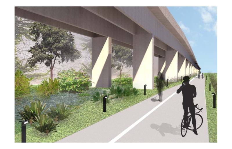
RESOLUTION DIRECTING THE COUNTY MAYOR OR COUNTY MAYOR’S DESIGNEE TO PREPARE A REPORT WITHIN SIXTY DAYS CONTAINING A POSSIBLE IMPLEMENTATION PLAN FOR CREATION OF A TEN-MILE LINEAR PARK ALONG THE METRORAIL CORRIDOR CONSISTENT WITH THE UNDERLINE (FORMERLY THE GREENLINK) PROPOSAL WHEREAS, the Friends of The Underline (formerly the GreenLink) have proposed an initiative to transform various lands underneath the MetroRail right-of-way into a contiguous ten-mile walkway, bike path, linear park, and transit mobility corridor from the Miami River north of the Brickell MetroRail Station to the Dadeland South MetroRail Station known as “The Underline”; and WHEREAS, this project is in keeping with the 2008 Miami-Dade County Parks and Open Spaces System Master Plan, which serves as the County’s framework for building a system of parks, public spaces, natural and cultural areas connected by greenways, waterways, trails and streets designated as linear parks in order to create a healthier, greener and a more economically vibrant place to live, work and play; and WHEREAS, this Board supports the goals of The Underline project in that it promotes health and well-being of County residents and visitors by providing a walkable, and bikable corridor that promotes mass transit opportunities ; and WHEREAS, The Underline will provide a world-class mulitmodal corridor and linear park modeled after successful linear parks such as the High Line in New York City and the 606 Trail in Chicago; and WHEREAS, The Underline would provide for a widened, straightened and lighted path, improved crosswalks, and transformation of the existing M-Path into a world-class public park space providing recreational options for pedestrians and cyclists in the heart of the urban core; and WHEREAS, the development of this public asset into a linear park would serve the community with purposeful green space and serve as a catalyst for meaningful mixed-use transit-oriented development of the eight Miami-Dade Transit MetroRail stations along the proposed path; and WHEREAS, the development of transit-oriented development at these MetroRail stations will create an urban environment for commuters, residents, workers, and visitors that integrates quality amenities and enhances lifestyle and mobility by providing easily-accessible transit connections to commercial, cultural and residential venues throughout the County; and WHEREAS, the project will create positive changes for the local community and environment whereby, according to the TrailBenefit estimate provided by Miami-Dade Parks, Recreation and Open Spaces Department, this ten-mile corridor and the expected enhanced transportation-oriented developments will reduce or eliminate 1.4 million motorized trips and 630 tons of carbon dioxide emissions, and save 60,000 gallons of fuel; and WHEREAS, the project will result in improvements to social, environmental, and economic conditions alongside U.S.